
 Svenska
 Dansk
Dansk
 Suomi
Suomi
 Deutsch
 Polskie
 Français
 Nederlands
 Italiano
 Español

Västerbotten is a landscape with greater variation than the map first suggests. Here there is a coast with polished boulders, deep forests, rivers with powerful rapids and heights that provide wide views. For hikers this is an advantage. You can choose an easy day trip near Umeå, a coastal hike with the sea as a landmark or a longer trip where weather and terrain require more planning.
It is also important to distinguish between the province of Västerbotten and the county of Västerbotten . Mountain areas such as Vindelfjällen are located in the province of Lapland, even though they belong to the county of Västerbotten. The highest point in the province is Åmliden, which is often stated to be 551 meters above sea level. The National Land Survey of Finland states the height at 550 meters.
Here are seven nature experiences to plan.
1. Björnlandets National Park – old-growth forest, ravines and old pine trees

Björnlandet National Park is one of Västerbotten's most obvious destinations for those who want to experience older forests. The national park is characterized by steep slopes, ravines, rocky areas and pine trees that have stood for a long time. In several places, traces of forest fires are also visible, which is a natural part of the forest's development.
There are several marked trails with different characteristics. The primeval forest trail at the entrance to Angsjö is suitable for a shorter excursion, while the Angsjöleden, Guldbäcksleden and Björnlandsleden provide more hiking for those who want to be out longer. There are bridges over wetter sections, but the terrain is not evenly easy everywhere.
What will the equipment have to handle? Roots, rocks, damp ground and changing temperatures. A pair of sturdy hiking shoes, rain gear and extra reinforcements are more important than squeezing every gram into your backpack. Read current information about trails and rules on the Swedish National Parks page about Björnlandet .
2. Tavelsjöleden – from Umeå to forest and heights
The Tavelsjöleden trail is approximately 42 kilometers long and begins in the center of Umeå, by the river below Väven. The trail then goes through urban environments, over more open land and further into the forest landscape towards Tavelsjöberget and Torrberget.
It is an unusually useful trail because you can choose your level of ambition. The entire trail requires more planning, while parts of the route work as a day trip. There are barbecue huts, shelters and rest areas along the trail. Tavelsjöberget reaches 284 meters above sea level and provides a clear viewpoint, although the elevation difference is moderate compared to mountain hiking.
The surface changes. Forest paths, road sections and footpaths and cycle paths place different demands on pace and footwear. Follow the markings carefully, especially where the trail leaves built-up areas. Umeå Municipality describes the route and refers to the map on the Tavelsjöleden page.
3. Vindelälven – river landscape from forest to coast
The Vindelälven is one of Sweden's great undeveloped rivers. It is not a single hiking trail with a standardized day's walk, but a larger landscape to explore through different trails, reserves and attractions. Rapids, beaches, ravines and forests give the tour a different rhythm than a hike across bare mountains.
For many hikers, the river is most interesting when combined with shorter stages. You can build a tour around a reserve, a shelter or a rest area and use the Nature Map for Västerbotten County to check current trails and facilities.
Water changes conditions. Beaches can be slippery, trails can be wet, and high water flows affect accessibility. Have a map even when the trail seems obvious. A dry sweater in your pack and a rain cover for your backpack are small measures that are clearly noticeable when the weather changes.
A geographical demarcation: The Vindelfjällen Mountains are located in Lapland
Vindelfjällen Nature Reserve geographically belongs to the province of Lapland , not Västerbotten. However, the area is located in Västerbotten County and is therefore relevant if you are planning a larger county trip. There you will find mountain ranges, higher altitude differences and more weather-exposed terrain than in the province of Västerbotten.
Don't mix up the areas when planning. A coastal or forest trip and a mountain trip don't require the same equipment, experience or margins.
4. Mårdseleforsen – bridges, cliffs and strong water
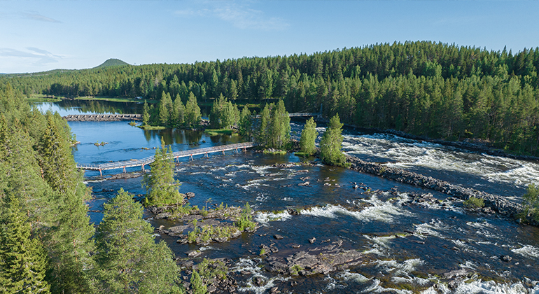
Mårdseleforsen Nature Reserve is an easily accessible way to experience the power of the Vindelälven River. The river divides between islands and cliffs, and marked paths lead over spans and bridges through the rapids landscape. There are also older pine trees, giant cauldrons and remains from the rafting era.
The area is great for a day trip or a rest stop, but don't let the easy access create a false sense of security. Rapid water is dangerous at close range. Keep your distance from the edge and follow the barriers and signs.
There is an important current operational information: according to the County Administrative Board's information from August 2026, all bridges except the two suspension bridges in the north are closed for safety reasons. Therefore, check Mårdseleforsen's current information before departure. Fires are only allowed in designated areas, and camping is limited according to the reserve's regulations.
5. Bjuröklubb – lighthouse, cliffs and land-raising coast
Bjuröklubb is one of Västerbotten's most characteristic coastal environments. At the lighthouse you will encounter open rocky areas, pebbles, sand dunes and gnarled trees shaped by wind and sea. The headland rose out of the sea through the land uplift, and the area also bears traces of older seal owners and fishermen.
Here you can combine a short excursion around the lighthouse with a longer hike in the reserve. However, the surface of the coast is uneven. Wet rocks become slippery, and the wind can be significantly stronger than inside the forest. Bring a windproof jacket even on a sunny day.
Bjuröklubb also has special rules for camping, lighting fires and parking. Follow the reserve's instructions and only use designated areas. Read more about Bjuröklubb at the County Administrative Board before planning your overnight stay.
6. Strömbäck–Kont – coastal hike near Umeå

Strömbäck–Kont gives you a coastal feel without a long journey from Umeå. The area consists of forest, cliffs, bays and beaches. A shorter path leads from Strömbäck down to the sea, and longer tours can provide a full-day trip with both forest and coast.
This is a good option when the group has different levels of experience. Those who want a short walk can stay close to Kont, while those who want more distance can choose a longer loop. Check the terrain before the trip. Coastal paths can be easy to walk one day and slippery after rain the next.
In nature reserves, the right of public access does not apply as an unlimited permit. Strömbäck–Kont has special rules for, among other things, fires, camping, dogs and collection. Read current information from Umeå Municipality and the County Administrative Board before you go.
7. Åmliden – Västerbotten's highest point
Åmliden in Norsjö municipality is the highest point in Västerbotten. The height is often given as 551 meters above sea level, while the National Land Survey of Sweden states it is 550 meters. The difference does not change the experience: from the top you get a clear view of the Västerbotten forest landscape.
Åmliden is not a mountain in the traditional sense. It is a forested elevation with roads, wind power and local trails in the vicinity. Therefore, the location is also suitable for those who want to make a shorter summit trip without venturing into high mountain terrain. Check local conditions, parking and the status of the trails before setting off. Norsjö municipality has information about hiking and outdoor activities .
Equipment and safety in Västerbotten
Västerbotten does not require the same packing in all places. Start with the question: What will the tour actually handle?
For a short coastal trip, comfortable shoes, wind and rain protection, water, a packed lunch and a charged phone with a map are often enough. For a longer forest trip, you need more: reinforcement clothing, first aid, a headlamp and a well-thought-out way to navigate if you leave the marked trail.
On multi-day trips, the big decisions are the most important: tent, sleeping system and backpack. A sleeping pad that is too thin can cause the ground to be cold and impair recovery, even if the backpack is lighter. When choosing a sleeping bag or other insulating sleeping system, you can read our guide on bird down in sleeping bags . For other planning, tents , backpacks and sleeping pads are collected at HikingStore.
Mosquitoes and gnats can be noticeable during the summer. Fall often brings fewer insects, but shorter days and faster temperature drops. On the coast, wind is a factor throughout the season. Regardless of your luck: check weather, trail status, reserve regulations and any closures before you set off.
The right of public access is based on consideration: do not disturb, do not destroy and leave the place as you found it. In national parks and nature reserves, the rules may be stricter. This is where balance becomes practical: choose equipment that provides margins, follow the markings and be prepared for changing weather conditions.