
 Svenska
 Dansk
Dansk
 Suomi
Suomi
 Deutsch
 Polskie
 Français
 Nederlands
 Italiano
 Español

Jämtland is the region where forest landscapes, mountains, waterfalls and limestone karst formations meet. Here you will find both well-marked trails with mountain stations and more demanding nature experiences where maps, weather forecasting and good planning are of greater importance.
This is the twentieth article in the series "Attractions in every landscape" . The series follows a line from south to north and has now reached Jämtland after, among others, Härjedalen, Medelpad and Ångermanland.
A geographical thing is worth clarifying from the beginning: Jämtland's landscape is not the same as Jämtland County . The county is larger and includes, among other things, Härjedalen. Sonfjället is therefore located in Härjedalen and does not belong in this article about Jämtland's landscape.
Jämtland's highest point is Storsylen , 1,743 meters above sea level on the Swedish side. The mountain's absolute peak reaches 1,762 meters, but is located in Norway. This difference reappears when you move around the Syl massif: the border on the map is clear, while the mountain terrain itself continues without regard to landscape boundaries.
1. Jämtland Triangle – classic hike between three mountain stations
The Jämtland Triangle runs between Storulvån, Sylarna and Blåhammaren . The approximately 47-kilometer round trip is usually divided into three days, with stages of approximately 12–19 kilometers.
It is a good introduction to mountain hiking as the trail is clear and accommodation is available along the way. You can hike with a lighter pack if you stay at the mountain stations, and at Storulvån, Sylarna and Blåhammaren there is the possibility to buy or cook food. STF still recommends that you plan lunches and breaks separately.
The first stage from Storulvån to Sylarna gradually ascends towards more open mountain terrain. From Sylarna to Blåhammaren the landscape becomes more rocky and exposed to wind. The final stage back to Storulvån is shorter, but fatigue can affect the pace even when the terrain looks easy.
Read STF's current information about the Jämtland Triangle before you leave. It contains information about stages, accommodation, maps and transport.
If you want to camp, you need to plan for more weight and greater weather exposure. A tent, an insulating sleeping pad and a sleeping bag that works in the lowest night temperature are more important than squeezing every gram. Please see HikingStore's tents , sleeping pads and sleeping bags . For technical differences between down types, CUIN and fill weight, there is also our guide to bird down in sleeping bags .
2. Vålådalen and Blanktjärnsrundan – mountain scenery at a reasonable distance
Vålådalen shows a different side of Jämtland than the highest mountains. Here you will find mountain birch forests, bogs, flowing water, mountain ranges and valleys. The area is suitable for both shorter day trips and longer trips towards Lunndörren, Anaris and Ottfjället.
The most famous day trip is the Blanktjärnsrundan , route 283. Expect about 12 kilometers and several hours of hiking. The destination is Östra Blanktjärnarna, whose clear waters give the lakes their characteristic turquoise color.
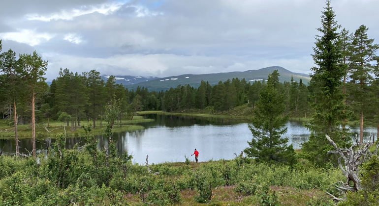
Blanktjärnarna is also an example of why nature conservation must outweigh the perfect picture. At Östra Blanktjärnarna, special rules apply. You must stay on the marked trail and viewpoint. It is not allowed to go down to the shore, swim, paddle or skate in the ponds.
The County Administrative Board describes Vålådalen Nature Reserve and the zones that govern where and how different activities can be carried out. Check the rules before the trip, as mobile coverage may be limited.
A small backpack, water, reinforcements and rain gear are often enough for the round. Still, choose shoes with good grip. Buckles can be slippery and the weather can change quickly. Balance here means packing lightly without depending on perfect conditions.
3. Åreskutan – views of mountains, valleys and lakes
Åreskutan rises above Åre and reaches approximately 1,420 meters above sea level. The mountain can be experienced in several ways: as a shorter tour with lift assistance or as a longer hike from a lower starting point.
At the top you get a view of Åre Valley and the surrounding mountains. However, a summit trip is not just about height. Wind, fog and temperature can change in a short time. It can be hot in Åre village while the summit has strong winds and significantly lower temperatures.
Bring a dry reinforcement layer in your backpack even on a sunny summer day. A wind and rainproof jacket, hat, gloves and map weigh little compared to the consequences of getting chilled on the way down. HikingStore's rainwear can be part of a working layer-on-layer system, but the garment must also work over the backpack and provide sufficient freedom of movement.
4. Tännforsen – large bodies of water near the road
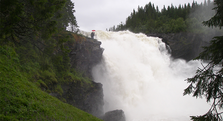
Tännforsen is located west of Åre and is one of Sweden's largest waterfalls. The water falls approximately 38 meters and the rapids are about 60 meters wide. During spring and early summer, the water flow can be particularly strong. In winter, the location changes when water and splashes form ice formations.
The visit does not require a long mountain hike. From the parking lot, walkways lead to the viewpoints, and the area also has adapted service on parts of the route. Therefore, Tännforsen serves as a good contrast to the Jämtland Triangle or Åreskutan.
It is still a place where you should keep your distance. Wet rock, the force of the rapids and steep edges leave little margin for a misstep. Follow paths, handrails and signs. Read the County Administrative Board's information about Tännforsen Nature Reserve before visiting.
5. Hällingsåfallet – waterfall in a deep canyon
In northern Jämtland, the Hällingsån River plunges over 40 meters into a deep canyon. The falls are located in a humid landscape where fog, moss and lichen give the place a special character.
The shortest path from the parking lot to the viewpoint is about 150 meters. If you want to experience more of the canyon, there is a steeper path along the river from the Hällarna rest area. This variant requires better balance and surer steps, especially after rain.
Hällingsåfallet is a good destination for those who want to combine a short walk with a clear nature experience. Sturdy shoes are still wise. The County Administrative Board's description of Hällingsåfallet contains information about trails, service and rules.
Fires are only allowed in designated areas. Please follow the instructions and do not go near the edge to get a better picture. A good nature experience should also be possible for the next visitor.
6. Coral Cave and the Bjurälven karst landscape – Jämtland below the ground surface
Northernmost Jämtland shows that the landscape is not just about mountain peaks and waterfalls. Here you will find Korallgrottan and the Bjurälven karst landscape, where calcareous bedrock has been shaped by water over a very long time.
Korallgrottan is Sweden's longest known cave , with passages of about five kilometers. The cave is locked and may only be visited with a guide. This is important both for safety and to protect the sensitive geological formations.
Bjurälven Nature Reserve is known for its limestone terrain, cracks, caves and watercourses that run partly underground. This is not a place where you should improvise your own caving trip. Follow the information on site and book a guide if you want to go into Korallgrottan.

Hiking poles are useful on the trails in the area, especially on uneven and wet ground. The County Administrative Board's information about Korallgrottans Nature Reserve describes the area's rules and how to get there.
7. Storsjöbygden and Andersön – lakeside nature near Östersund
The Storsjöbygden area gives Jämtland a gentler end. Around Storsjön there are forests, beaches, islands and open views of the mountains. At Andersön Nature Reserve you can combine an easy hike with a break, swimming and views of the lake.
Tours on Andersön vary depending on the route chosen, but the area is well suited for a day trip when you don't want to carry heavy luggage or walk far on bare mountains. Frösön and other places around Storsjön provide additional opportunities for shorter walks.
Comfortable hiking shoes, water and warm clothing are usually sufficient. A map is still a good idea, especially if you want to leave the most obvious trails. Read more about hiking around Storsjön and plan your trip based on weather, daylight and the pace of the group.
Equipment and safety in Jämtland
Jämtland does not require the same equipment on every tour. Start with the question: What will the tour actually handle?
For a short excursion to Tännforsen you don't need the same packing as for three days in the Jämtland Triangle. For a peak day on Åreskutan you need more margin for wind and cold. For the Coral Cave you need to follow the guide's requirements, not choose equipment on your own.
On longer trips, basic equipment should include:
- wind and rainproof outerwear
- warm reinforcement, hat and gloves
- map and compass as well as charged phone or GPS
- first aid and abrasion plasters
- headlamp, even on bright summer nights
- enough water and energy-rich food
- shoes with good grip and space for dry socks
- tent, sleeping bag and sleeping pad suitable for the seasonal temperatures
Check the weather forecast, trail status and local regulations before setting off. Inform someone about the itinerary on longer trips. Reindeer herding is carried out in several areas. Keep your distance from reindeer, let them pass and take a detour if necessary.
Jämtland rewards those who plan, but does not punish those who choose a shorter trip. The best equipment is not the lightest on paper. It is the one that works when the rain comes, the wind increases and your legs start to get tired.